


autour de Montsec

kikkko
User
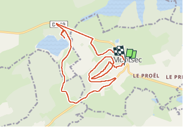

Length
10.4 km

Max alt
376 m

Uphill gradient
227 m
Km-Effort
13.4 km

Min alt
227 m

Downhill gradient
237 m
Boucle
Yes
Creation date :
2025-04-21 07:05:20.977
Updated on :
2025-04-21 10:32:06.602
2h50
Difficulty : Difficult

FREE GPS app for hiking
 SityTrail
IGN / Geographical institutes
SityTrail Plus
The world is yours!
About
Trail Walking of 10.4 km to be discovered at Grand Est, Meuse, Montsec. This trail is proposed by kikkko.
Description
balade sympa autour du Mont Sec
Positioning
Country:
France
Region :
Grand Est
Department/Province :
Meuse
Municipality :
Montsec
Location:
Unknown
Start:(Dec)
Start:(UTM)
699305 ; 5418810 (31U) N.
Comments