


Lacoste circuit n° 48 Pont Julien

tercla
User
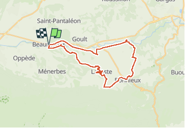

Length
32 km

Max alt
360 m

Uphill gradient
531 m
Km-Effort
39 km

Min alt
121 m

Downhill gradient
535 m
Boucle
Yes
Creation date :
2025-04-22 07:09:30.15
Updated on :
2025-04-24 16:58:48.943
2h42
Difficulty : Difficult

FREE GPS app for hiking
 SityTrail
IGN / Geographical institutes
SityTrail Plus
The world is yours!
About
Trail Mountain bike of 32 km to be discovered at Provence-Alpes-Côte d'Azur, Vaucluse, Beaumettes. This trail is proposed by tercla.
Photos


Positioning
Country:
France
Region :
Provence-Alpes-Côte d'Azur
Department/Province :
Vaucluse
Municipality :
Beaumettes
Location:
Unknown
Start:(Dec)
Start:(UTM)
677000 ; 4858450 (31T) N.
Comments