


Nesles Labbevile

avdem
User
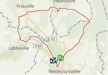

Length
9.6 km

Max alt
109 m

Uphill gradient
167 m
Km-Effort
11.9 km

Min alt
38 m

Downhill gradient
168 m
Boucle
Yes
Creation date :
2025-04-22 07:16:21.446
Updated on :
2025-04-22 09:59:04.829
2h41
Difficulty : Easy

FREE GPS app for hiking
 SityTrail
IGN / Geographical institutes
SityTrail Plus
The world is yours!
About
Trail Walking of 9.6 km to be discovered at Ile-de-France, Val-d'Oise, Nesles-la-Vallée. This trail is proposed by avdem.
Description
facile
Photos


Positioning
Country:
France
Region :
Ile-de-France
Department/Province :
Val-d'Oise
Municipality :
Nesles-la-Vallée
Location:
Unknown
Start:(Dec)
Start:(UTM)
439200 ; 5442285 (31U) N.
Comments