


sommet des 4 termes

franquen
User

Length
14.4 km

Max alt
1884 m

Uphill gradient
899 m
Km-Effort
26 km

Min alt
1030 m

Downhill gradient
900 m
Boucle
Yes
Creation date :
2025-04-22 06:42:50.489
Updated on :
2025-04-22 12:54:47.569
6h11
Difficulty : Very difficult

FREE GPS app for hiking
 SityTrail
IGN / Geographical institutes
SityTrail Plus
The world is yours!
About
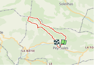
Trail Walking of 14.4 km to be discovered at Provence-Alpes-Côte d'Azur, Alpes-de-Haute-Provence, Peyroules. This trail is proposed by franquen.
Positioning
Country:
France
Region :
Provence-Alpes-Côte d'Azur
Department/Province :
Alpes-de-Haute-Provence
Municipality :
Peyroules
Location:
Unknown
Start:(Dec)
Start:(UTM)
310318 ; 4854064 (32T) N.
Comments