


viols le fort cambous

labarone
User

Length
21 km

Max alt
531 m

Uphill gradient
431 m
Km-Effort
26 km

Min alt
239 m

Downhill gradient
431 m
Boucle
Yes
Creation date :
2025-04-22 06:34:47.852
Updated on :
2025-04-22 13:18:51.078
6h13
Difficulty : Medium

FREE GPS app for hiking
 SityTrail
IGN / Geographical institutes
SityTrail Plus
The world is yours!
About
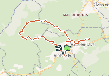
Trail Walking of 21 km to be discovered at Occitania, Hérault, Viols-le-Fort. This trail is proposed by labarone.
Description
belle vue sur pic
saint loup
viols le fort à visiter
Positioning
Country:
France
Region :
Occitania
Department/Province :
Hérault
Municipality :
Viols-le-Fort
Location:
Unknown
Start:(Dec)
Start:(UTM)
556554 ; 4843576 (31T) N.
Comments