


Douelle

cps46
User
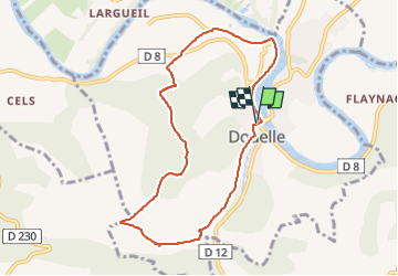

Length
8.5 km

Max alt
296 m

Uphill gradient
203 m
Km-Effort
11.2 km

Min alt
104 m

Downhill gradient
202 m
Boucle
Yes
Creation date :
2025-04-23 15:34:46.0
Updated on :
2025-04-23 16:35:59.437

FREE GPS app for hiking
 SityTrail
IGN / Geographical institutes
SityTrail Plus
The world is yours!
About
Trail of 8.5 km to be discovered at Occitania, Lot, Douelle. This trail is proposed by cps46.
Positioning
Country:
France
Region :
Occitania
Department/Province :
Lot
Municipality :
Douelle
Location:
Unknown
Start:(Dec)
Start:(UTM)
369597 ; 4925513 (31T) N.
Comments