


Cournon puy d'Anzelle puy de Banne 9 km 250 dénivelé

jeanic63
User
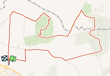

Length
8.1 km

Max alt
531 m

Uphill gradient
242 m
Km-Effort
11.3 km

Min alt
378 m

Downhill gradient
241 m
Boucle
Yes
Creation date :
2025-04-24 11:13:50.085
Updated on :
2025-04-24 16:58:20.789
2h33
Difficulty : Medium

FREE GPS app for hiking
 SityTrail
IGN / Geographical institutes
SityTrail Plus
The world is yours!
About
Trail Walking of 8.1 km to be discovered at Auvergne-Rhône-Alpes, Puy-de-Dôme, Cournon-d'Auvergne. This trail is proposed by jeanic63.
Description
départ Cournon rond point avenue de Clermont
Positioning
Country:
France
Region :
Auvergne-Rhône-Alpes
Department/Province :
Puy-de-Dôme
Municipality :
Cournon-d'Auvergne
Location:
Unknown
Start:(Dec)
Start:(UTM)
513239 ; 5066111 (31T) N.
Comments