calèche option 2 2025

Rémy Isenmann
User
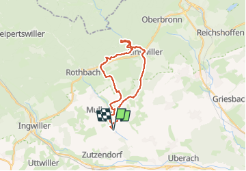

Length
22 km

Max alt
300 m

Uphill gradient
455 m
Km-Effort
28 km

Min alt
176 m

Downhill gradient
455 m
Boucle
Yes
Creation date :
2025-04-24 17:08:03.671
Updated on :
2025-04-24 17:09:59.287
0m
Difficulty : Very easy

FREE GPS app for hiking
 SityTrail
IGN / Geographical institutes
SityTrail Plus
The world is yours!
About
Trail Coupling of 22 km to be discovered at Grand Est, Bas-Rhin, Uhrwiller. This trail is proposed by Rémy Isenmann.
Description
Niefern , Zinswiller , Offwiller Niefern
Positioning
Country:
France
Region :
Grand Est
Department/Province :
Bas-Rhin
Municipality :
Uhrwiller
Location:
Unknown
Start:(Dec)
Start:(UTM)
394418 ; 5413870 (32U) N.
Comments