


St germain,Montillon,Monhabeul,jardin d'eau,12km PB

COGLAIS3
User
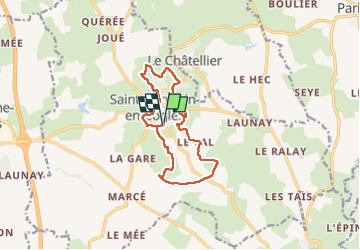

Length
12.1 km

Max alt
194 m

Uphill gradient
196 m
Km-Effort
14.7 km

Min alt
120 m

Downhill gradient
196 m
Boucle
Yes
Creation date :
2025-04-24 07:00:21.398
Updated on :
2025-04-25 06:57:14.39
2h20
Difficulty : Very easy

FREE GPS app for hiking
 SityTrail
IGN / Geographical institutes
SityTrail Plus
The world is yours!
About
Trail Nordic walking of 12.1 km to be discovered at Brittany, Ille-et-Vilaine, Saint-Germain-en-Coglès. This trail is proposed by COGLAIS3.
Positioning
Country:
France
Region :
Brittany
Department/Province :
Ille-et-Vilaine
Municipality :
Saint-Germain-en-Coglès
Location:
Unknown
Start:(Dec)
Start:(UTM)
628709 ; 5362318 (30U) N.
Comments