


plateau de Savel

crocau
User
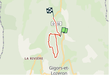

Length
4.5 km

Max alt
770 m

Uphill gradient
103 m
Km-Effort
5.8 km

Min alt
669 m

Downhill gradient
75 m
Boucle
No
Creation date :
2025-04-25 11:31:32.11
Updated on :
2025-04-25 15:16:24.84
2h48
Difficulty : Very easy

FREE GPS app for hiking
 SityTrail
IGN / Geographical institutes
SityTrail Plus
The world is yours!
About
Trail Walking of 4.5 km to be discovered at Auvergne-Rhône-Alpes, Drôme, Gigors-et-Lozeron. This trail is proposed by crocau.
Positioning
Country:
France
Region :
Auvergne-Rhône-Alpes
Department/Province :
Drôme
Municipality :
Gigors-et-Lozeron
Location:
Unknown
Start:(Dec)
Start:(UTM)
666719 ; 4963663 (31T) N.
Comments
C'est une rando balade pour observer les animaux. Une très bonne idée aussi pour du camping sauvage.