


langon No6 decouvrrte

durmord
User
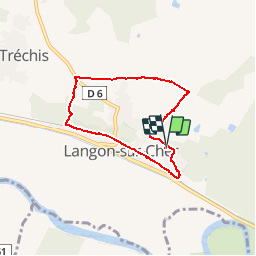

Length
5.8 km

Max alt
130 m

Uphill gradient
62 m
Km-Effort
6.6 km

Min alt
91 m

Downhill gradient
61 m
Boucle
Yes
Creation date :
2019-04-28 13:04:06.284
Updated on :
2019-04-28 13:04:06.324
55m
Difficulty : Medium

FREE GPS app for hiking
 SityTrail
IGN / Geographical institutes
SityTrail Plus
The world is yours!
About
Trail Walking of 5.8 km to be discovered at Centre-Loire Valley, Loir-et-Cher, Langon-sur-Cher. This trail is proposed by durmord.
Positioning
Country:
France
Region :
Centre-Loire Valley
Department/Province :
Loir-et-Cher
Municipality :
Langon-sur-Cher
Location:
Unknown
Start:(Dec)
Start:(UTM)
411876 ; 5237394 (31T) N.
Comments