


menerval

Laurent53
User
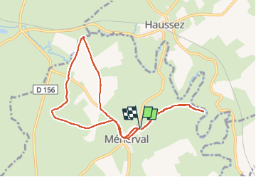

Length
8.7 km

Max alt
182 m

Uphill gradient
128 m
Km-Effort
10.4 km

Min alt
116 m

Downhill gradient
123 m
Boucle
Yes
Creation date :
2025-04-27 07:42:31.854
Updated on :
2025-04-27 10:38:05.314
2h54
Difficulty : Medium

FREE GPS app for hiking
 SityTrail
IGN / Geographical institutes
SityTrail Plus
The world is yours!
About
Trail Walking of 8.7 km to be discovered at Normandy, Seine-Maritime, Ménerval. This trail is proposed by Laurent53.
Positioning
Country:
France
Region :
Normandy
Department/Province :
Seine-Maritime
Municipality :
Ménerval
Location:
Unknown
Start:(Dec)
Start:(UTM)
403127 ; 5491246 (31U) N.
Comments