


Gespunsart-France 08

fra_depoorter
User
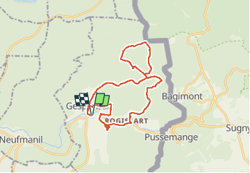

Length
15 km

Max alt
369 m

Uphill gradient
375 m
Km-Effort
20 km

Min alt
196 m

Downhill gradient
376 m
Boucle
Yes
Creation date :
2025-04-27 07:28:52.661
Updated on :
2025-04-29 06:11:45.78
3h32
Difficulty : Medium

FREE GPS app for hiking
 SityTrail
IGN / Geographical institutes
SityTrail Plus
The world is yours!
About
Trail Walking of 15 km to be discovered at Grand Est, Ardennes, Gespunsart. This trail is proposed by fra_depoorter.
Description
Très belle balade près de Pussemange et Bagimont (Vresse/Semois)
Positioning
Country:
France
Region :
Grand Est
Department/Province :
Ardennes
Municipality :
Gespunsart
Location:
Unknown
Start:(Dec)
Start:(UTM)
631691 ; 5520002 (31U) N.
Comments