


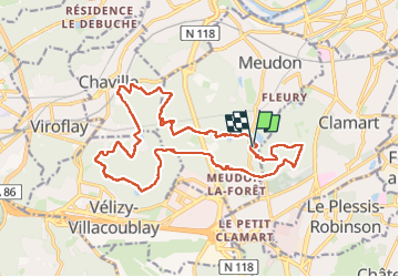
R1T-JG53S Forêt de Meudon

Jack-94
User

Length
19.5 km

Max alt
187 m

Uphill gradient
364 m
Km-Effort
24 km

Min alt
112 m

Downhill gradient
363 m
Boucle
Yes
Creation date :
2025-04-27 06:43:07.178
Updated on :
2025-04-27 16:49:26.065
6h46
Difficulty : Very difficult

FREE GPS app for hiking
 SityTrail
IGN / Geographical institutes
SityTrail Plus
The world is yours!
About
Trail Walking of 19.5 km to be discovered at Ile-de-France, Hauts-de-Seine, Meudon. This trail is proposed by Jack-94.

Positioning
Country:
France
Region :
Ile-de-France
Department/Province :
Hauts-de-Seine
Municipality :
Meudon
Location:
Unknown
Start:(Dec)
Start:(UTM)
443690 ; 5404991 (31U) N.
Comments