


SityTrail - Laborie Gaillac

CANON2
User
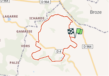

Length
8.7 km

Max alt
278 m

Uphill gradient
231 m
Km-Effort
11.8 km

Min alt
179 m

Downhill gradient
231 m
Boucle
Yes
Creation date :
2025-04-28 14:19:04.284
Updated on :
2025-04-28 14:19:51.866
2h41
Difficulty : Easy

FREE GPS app for hiking
 SityTrail
IGN / Geographical institutes
SityTrail Plus
The world is yours!
About
Trail On foot of 8.7 km to be discovered at Occitania, Tarn, Gaillac. This trail is proposed by CANON2.
Description
Marche nordique
Positioning
Country:
France
Region :
Occitania
Department/Province :
Tarn
Municipality :
Gaillac
Location:
Unknown
Start:(Dec)
Start:(UTM)
410107 ; 4866096 (31T) N.
Comments