


Lac des Monges

rigol05
User

Length
12.4 km

Max alt
1605 m

Uphill gradient
650 m
Km-Effort
21 km

Min alt
1114 m

Downhill gradient
646 m
Boucle
Yes
Creation date :
2015-07-11 00:00:00.0
Updated on :
2015-07-11 00:00:00.0
4h24
Difficulty : Medium

FREE GPS app for hiking
 SityTrail
IGN / Geographical institutes
SityTrail Plus
The world is yours!
About
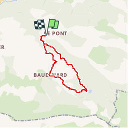
Trail Walking of 12.4 km to be discovered at Provence-Alpes-Côte d'Azur, Alpes-de-Haute-Provence, Bayons. This trail is proposed by rigol05.
Description
Randonnée du 10/07/2015
Le sentier aléatoire passant par le Rocher de Cournaud est inexistant(dommage!), il est préférable de suivre le GR par la piste.
Positioning
Country:
France
Region :
Provence-Alpes-Côte d'Azur
Department/Province :
Alpes-de-Haute-Provence
Municipality :
Bayons
Location:
Esparron-la-Bâtie
Start:(Dec)
Start:(UTM)
272827 ; 4910176 (32T) N.
Comments