


28-07

DaVinci
User

Length
132 km

Max alt
264 m

Uphill gradient
1436 m
Km-Effort
151 km

Min alt
98 m

Downhill gradient
1442 m
Boucle
No
Creation date :
2025-04-28 13:51:14.62
Updated on :
2025-05-10 11:24:27.133
3h51
Difficulty : Very easy

FREE GPS app for hiking
 SityTrail
IGN / Geographical institutes
SityTrail Plus
The world is yours!
About
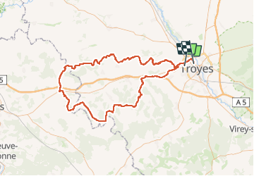
Trail Motorbike of 132 km to be discovered at Grand Est, Aube, Sainte-Savine. This trail is proposed by DaVinci.
Positioning
Country:
France
Region :
Grand Est
Department/Province :
Aube
Municipality :
Sainte-Savine
Location:
Unknown
Start:(Dec)
Start:(UTM)
576079 ; 5350514 (31U) N.
Comments