


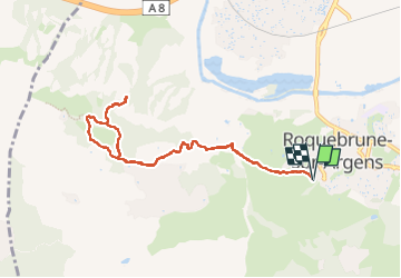
3 croix roquebrune

Canard83
User

Length
9.2 km

Max alt
334 m

Uphill gradient
365 m
Km-Effort
14 km

Min alt
15 m

Downhill gradient
365 m
Boucle
Yes
Creation date :
2025-04-25 07:59:24.719
Updated on :
2025-04-29 14:14:33.402
3h29
Difficulty : Difficult

FREE GPS app for hiking
 SityTrail
IGN / Geographical institutes
SityTrail Plus
The world is yours!
About
Trail Walking of 9.2 km to be discovered at Provence-Alpes-Côte d'Azur, Var, Roquebrune-sur-Argens. This trail is proposed by Canard83.
Positioning
Country:
France
Region :
Provence-Alpes-Côte d'Azur
Department/Province :
Var
Municipality :
Roquebrune-sur-Argens
Location:
Unknown
Start:(Dec)
Start:(UTM)
308430 ; 4812401 (32T) N.
Comments