


les cadieres de Brandis

franquen
User
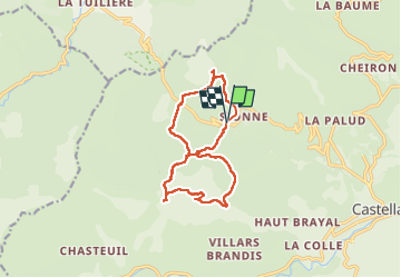

Length
13.9 km

Max alt
1558 m

Uphill gradient
653 m
Km-Effort
23 km

Min alt
1055 m

Downhill gradient
654 m
Boucle
Yes
Creation date :
2025-04-29 07:18:26.987
Updated on :
2025-04-29 14:36:19.844
5h08
Difficulty : Very difficult

FREE GPS app for hiking
 SityTrail
IGN / Geographical institutes
SityTrail Plus
The world is yours!
About
Trail Walking of 13.9 km to be discovered at Provence-Alpes-Côte d'Azur, Alpes-de-Haute-Provence, Castellane. This trail is proposed by franquen.
Positioning
Country:
France
Region :
Provence-Alpes-Côte d'Azur
Department/Province :
Alpes-de-Haute-Provence
Municipality :
Castellane
Location:
Unknown
Start:(Dec)
Start:(UTM)
296240 ; 4860084 (32T) N.
Comments