


Le puits du diable. départ. Le Faz

philou68
User
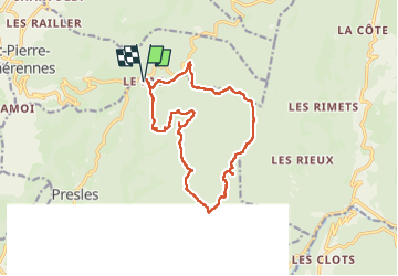

Length
14.7 km

Max alt
1381 m

Uphill gradient
590 m
Km-Effort
23 km

Min alt
995 m

Downhill gradient
587 m
Boucle
Yes
Creation date :
2025-04-30 06:28:44.191
Updated on :
2025-04-30 13:23:51.661
6h54
Difficulty : Easy

FREE GPS app for hiking
 SityTrail
IGN / Geographical institutes
SityTrail Plus
The world is yours!
About
Trail Walking of 14.7 km to be discovered at Auvergne-Rhône-Alpes, Isère, Presles. This trail is proposed by philou68.
Description
belle randonnée dans les hêtres
Positioning
Country:
France
Region :
Auvergne-Rhône-Alpes
Department/Province :
Isère
Municipality :
Presles
Location:
Unknown
Start:(Dec)
Start:(UTM)
689100 ; 4998671 (31T) N.
Comments