


Castres sidobre

Glurps
User
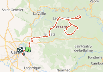

Length
48 km

Max alt
667 m

Uphill gradient
913 m
Km-Effort
60 km

Min alt
177 m

Downhill gradient
912 m
Boucle
Yes
Creation date :
2025-04-30 09:28:13.0
Updated on :
2025-04-30 16:24:59.281

FREE GPS app for hiking
 SityTrail
IGN / Geographical institutes
SityTrail Plus
The world is yours!
About
Trail of 48 km to be discovered at Occitania, Tarn, Castres. This trail is proposed by Glurps.
Positioning
Country:
France
Region :
Occitania
Department/Province :
Tarn
Municipality :
Castres
Location:
Unknown
Start:(Dec)
Start:(UTM)
440055 ; 4827601 (31T) N.
Comments