


CRET D'EAU

Jean-Paulchoux
User
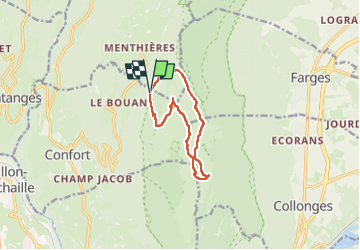

Length
9.7 km

Max alt
1610 m

Uphill gradient
452 m
Km-Effort
15.7 km

Min alt
1243 m

Downhill gradient
450 m
Boucle
Yes
Creation date :
2025-05-01 07:52:56.617
Updated on :
2025-05-01 13:08:06.857
3h20
Difficulty : Medium

FREE GPS app for hiking
 SityTrail
IGN / Geographical institutes
SityTrail Plus
The world is yours!
About
Trail Walking of 9.7 km to be discovered at Auvergne-Rhône-Alpes, Ain, Confort. This trail is proposed by Jean-Paulchoux.
Positioning
Country:
France
Region :
Auvergne-Rhône-Alpes
Department/Province :
Ain
Municipality :
Confort
Location:
Unknown
Start:(Dec)
Start:(UTM)
720081 ; 5116298 (31T) N.
Comments