


nice

doudet
User
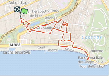

Length
3.5 km

Max alt
25 m

Uphill gradient
46 m
Km-Effort
4.2 km

Min alt
4 m

Downhill gradient
45 m
Boucle
Yes
Creation date :
2025-05-01 12:41:15.146
Updated on :
2025-05-01 17:13:01.952
2h42
Difficulty : Easy

FREE GPS app for hiking
 SityTrail
IGN / Geographical institutes
SityTrail Plus
The world is yours!
About
Trail Walking of 3.5 km to be discovered at Provence-Alpes-Côte d'Azur, Maritime Alps, Nice. This trail is proposed by doudet.
Positioning
Country:
France
Region :
Provence-Alpes-Côte d'Azur
Department/Province :
Maritime Alps
Municipality :
Nice
Location:
Unknown
Start:(Dec)
Start:(UTM)
360547 ; 4839772 (32T) N.
Comments