


Wikiloc Walenbos en Troostembergbos (PVDB)

Peter.vdbergh
User GUIDE
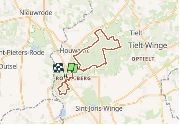

Length
13.4 km

Max alt
95 m

Uphill gradient
162 m
Km-Effort
15.6 km

Min alt
21 m

Downhill gradient
163 m
Boucle
Yes
Creation date :
2025-05-01 12:14:29.677
Updated on :
2025-05-01 17:18:56.06
3h17
Difficulty : Medium

FREE GPS app for hiking
 SityTrail
IGN / Geographical institutes
SityTrail Plus
The world is yours!
About
Trail Walking of 13.4 km to be discovered at Flanders, Flemish Brabant, Tielt-Winge. This trail is proposed by Peter.vdbergh.
Positioning
Country:
Belgium
Region :
Flanders
Department/Province :
Flemish Brabant
Municipality :
Tielt-Winge
Location:
Houwaart
Start:(Dec)
Start:(UTM)
630288 ; 5642630 (31U) N.
Comments