


Rando bbq Epinal

lorenzot54
User
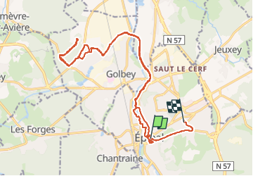

Length
23 km

Max alt
381 m

Uphill gradient
249 m
Km-Effort
26 km

Min alt
311 m

Downhill gradient
200 m
Boucle
No
Creation date :
2025-05-02 17:40:03.0
Updated on :
2025-05-02 21:38:34.071

FREE GPS app for hiking
 SityTrail
IGN / Geographical institutes
SityTrail Plus
The world is yours!
About
Trail of 23 km to be discovered at Grand Est, Vosges, Épinal. This trail is proposed by lorenzot54.
Description
Rando nuit 29 km fort de Haye
Positioning
Country:
France
Region :
Grand Est
Department/Province :
Vosges
Municipality :
Épinal
Location:
Unknown
Start:(Dec)
Start:(UTM)
310521 ; 5338853 (32U) N.
Comments