


frejus

doudet
User
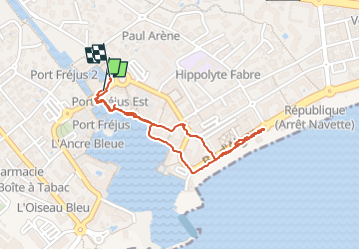

Length
1.8 km

Max alt
11 m

Uphill gradient
10 m
Km-Effort
2 km

Min alt
1 m

Downhill gradient
9 m
Boucle
Yes
Creation date :
2025-05-04 09:21:05.501
Updated on :
2025-05-04 10:48:33.127
1h27
Difficulty : Easy

FREE GPS app for hiking
 SityTrail
IGN / Geographical institutes
SityTrail Plus
The world is yours!
About
Trail Walking of 1.8 km to be discovered at Provence-Alpes-Côte d'Azur, Var, Fréjus. This trail is proposed by doudet.
Positioning
Country:
France
Region :
Provence-Alpes-Côte d'Azur
Department/Province :
Var
Municipality :
Fréjus
Location:
Unknown
Start:(Dec)
Start:(UTM)
317596 ; 4810342 (32T) N.
Comments