


SityTrail - Hatrival02

Thyves
User
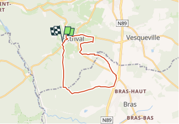

Length
11.9 km

Max alt
554 m

Uphill gradient
227 m
Km-Effort
14.9 km

Min alt
412 m

Downhill gradient
228 m
Boucle
Yes
Creation date :
2025-05-04 13:08:44.42
Updated on :
2025-05-04 13:47:25.104
3h23
Difficulty : Difficult

FREE GPS app for hiking
 SityTrail
IGN / Geographical institutes
SityTrail Plus
The world is yours!
About
Trail Walking of 11.9 km to be discovered at Wallonia, Luxembourg, Saint-Hubert. This trail is proposed by Thyves.
Positioning
Country:
Belgium
Region :
Wallonia
Department/Province :
Luxembourg
Municipality :
Saint-Hubert
Location:
Unknown
Start:(Dec)
Start:(UTM)
667767 ; 5541650 (31U) N.
Comments
Un petit sentier n’existe plus