


SityTrail - Hatrival04

Thyves
User
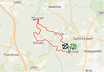

Length
27 km

Max alt
480 m

Uphill gradient
644 m
Km-Effort
36 km

Min alt
266 m

Downhill gradient
648 m
Boucle
Yes
Creation date :
2025-05-04 14:15:26.961
Updated on :
2025-05-04 16:22:48.83
8h07
Difficulty : Very difficult

FREE GPS app for hiking
 SityTrail
IGN / Geographical institutes
SityTrail Plus
The world is yours!
About
Trail Walking of 27 km to be discovered at Wallonia, Luxembourg, Saint-Hubert. This trail is proposed by Thyves.
Description
Pour les courageux et aventuriers
Positioning
Country:
Belgium
Region :
Wallonia
Department/Province :
Luxembourg
Municipality :
Saint-Hubert
Location:
Unknown
Start:(Dec)
Start:(UTM)
667802 ; 5541614 (31U) N.
Comments