


DUBLIN le retour

marmotte65
User GUIDE
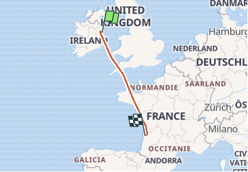

Length
1098 km
Boucle
No
Creation date :
2025-05-03 06:25:37.513
Updated on :
2025-05-05 06:11:16.025
1h50
Difficulty : Very easy

FREE GPS app for hiking
 SityTrail
IGN / Geographical institutes
SityTrail Plus
The world is yours!
About
Trail Plane of 1098 km to be discovered at Unknown, County Dublin, Unknown. This trail is proposed by marmotte65.
Positioning
Country:
Ireland
Region :
Unknown
Department/Province :
County Dublin
Municipality :
Unknown
Location:
Airport ED
Start:(Dec)
Start:(UTM)
683349 ; 5922926 (29U) N.
Comments