


T-JG-A517 Forêt de Meudon

Jack-94
User
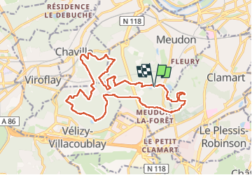

Length
18.5 km

Max alt
187 m

Uphill gradient
372 m
Km-Effort
23 km

Min alt
109 m

Downhill gradient
373 m
Boucle
Yes
Creation date :
2025-05-04 07:00:44.484
Updated on :
2025-05-05 19:13:29.174
7h14
Difficulty : Very difficult

FREE GPS app for hiking
 SityTrail
IGN / Geographical institutes
SityTrail Plus
The world is yours!
About
Trail Walking of 18.5 km to be discovered at Ile-de-France, Hauts-de-Seine, Meudon. This trail is proposed by Jack-94.
Positioning
Country:
France
Region :
Ile-de-France
Department/Province :
Hauts-de-Seine
Municipality :
Meudon
Location:
Unknown
Start:(Dec)
Start:(UTM)
443285 ; 5405209 (31U) N.
Comments