


Mours Presles

avdem
User
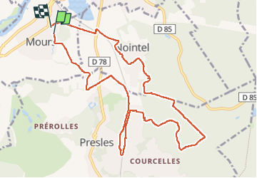

Length
10.9 km

Max alt
155 m

Uphill gradient
166 m
Km-Effort
13.2 km

Min alt
29 m

Downhill gradient
172 m
Boucle
Yes
Creation date :
2025-05-06 07:21:43.604
Updated on :
2025-05-06 10:42:14.071
3h19
Difficulty : Easy

FREE GPS app for hiking
 SityTrail
IGN / Geographical institutes
SityTrail Plus
The world is yours!
About
Trail Walking of 10.9 km to be discovered at Ile-de-France, Val-d'Oise, Mours. This trail is proposed by avdem.
Description
facile bien
Positioning
Country:
France
Region :
Ile-de-France
Department/Province :
Val-d'Oise
Municipality :
Mours
Location:
Unknown
Start:(Dec)
Start:(UTM)
446845 ; 5442370 (31U) N.
Comments