


Gluiras

raygautier
User
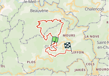

Length
17.7 km

Max alt
985 m

Uphill gradient
558 m
Km-Effort
26 km

Min alt
512 m

Downhill gradient
758 m
Boucle
No
Creation date :
2025-05-08 06:59:09.0
Updated on :
2025-05-08 11:23:22.53
4h23
Difficulty : Very difficult

FREE GPS app for hiking
 SityTrail
IGN / Geographical institutes
SityTrail Plus
The world is yours!
About
Trail Walking of 17.7 km to be discovered at Auvergne-Rhône-Alpes, Ardèche, Gluiras. This trail is proposed by raygautier.
Positioning
Country:
France
Region :
Auvergne-Rhône-Alpes
Department/Province :
Ardèche
Municipality :
Gluiras
Location:
Unknown
Start:(Dec)
Start:(UTM)
620387 ; 4967100 (31T) N.
Comments