


Puy de Tourettes depuis Saint Barnabé

alainfauvet
User
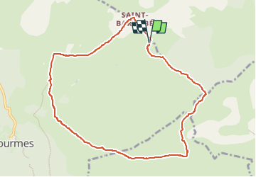

Length
10 km

Max alt
1263 m

Uphill gradient
371 m
Km-Effort
15 km

Min alt
933 m

Downhill gradient
370 m
Boucle
Yes
Creation date :
2025-05-08 11:50:56.425
Updated on :
2025-05-08 11:52:14.865
3h24
Difficulty : Difficult

FREE GPS app for hiking
 SityTrail
IGN / Geographical institutes
SityTrail Plus
The world is yours!
About
Trail Walking of 10 km to be discovered at Provence-Alpes-Côte d'Azur, Maritime Alps, Courmes. This trail is proposed by alainfauvet.
Positioning
Country:
France
Region :
Provence-Alpes-Côte d'Azur
Department/Province :
Maritime Alps
Municipality :
Courmes
Location:
Unknown
Start:(Dec)
Start:(UTM)
342397 ; 4847085 (32T) N.
Comments