


gigondas 2

raygautier
User
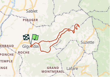

Length
15.7 km

Max alt
715 m

Uphill gradient
672 m
Km-Effort
25 km

Min alt
229 m

Downhill gradient
674 m
Boucle
Yes
Creation date :
2025-04-25 06:14:20.373
Updated on :
2025-05-08 12:34:02.219
8h58
Difficulty : Very difficult

FREE GPS app for hiking
 SityTrail
IGN / Geographical institutes
SityTrail Plus
The world is yours!
About
Trail Walking of 15.7 km to be discovered at Provence-Alpes-Côte d'Azur, Vaucluse, Gigondas. This trail is proposed by raygautier.
Positioning
Country:
France
Region :
Provence-Alpes-Côte d'Azur
Department/Province :
Vaucluse
Municipality :
Gigondas
Location:
Unknown
Start:(Dec)
Start:(UTM)
660321 ; 4892219 (31T) N.
Comments