


gluiras

raygautier
User
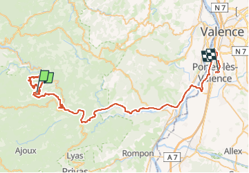

Length
67 km

Max alt
985 m

Uphill gradient
944 m
Km-Effort
82 km

Min alt
93 m

Downhill gradient
1643 m
Boucle
No
Creation date :
2025-05-08 06:59:59.609
Updated on :
2025-05-08 12:34:06.531
5h33
Difficulty : Very difficult

FREE GPS app for hiking
 SityTrail
IGN / Geographical institutes
SityTrail Plus
The world is yours!
About
Trail Walking of 67 km to be discovered at Auvergne-Rhône-Alpes, Ardèche, Gluiras. This trail is proposed by raygautier.
Positioning
Country:
France
Region :
Auvergne-Rhône-Alpes
Department/Province :
Ardèche
Municipality :
Gluiras
Location:
Unknown
Start:(Dec)
Start:(UTM)
620378 ; 4967108 (31T) N.
Comments