


La Chapelle de Montfort par Pressiat

MarcVachet
User
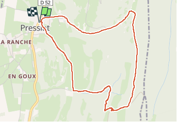

Length
5.4 km

Max alt
596 m

Uphill gradient
267 m
Km-Effort
9 km

Min alt
345 m

Downhill gradient
267 m
Boucle
Yes
Creation date :
2025-05-08 11:44:24.0
Updated on :
2025-05-08 13:55:47.876
2h03
Difficulty : Very easy

FREE GPS app for hiking
 SityTrail
IGN / Geographical institutes
SityTrail Plus
The world is yours!
About
Trail Walking of 5.4 km to be discovered at Auvergne-Rhône-Alpes, Ain, Val-Revermont. This trail is proposed by MarcVachet.
Positioning
Country:
France
Region :
Auvergne-Rhône-Alpes
Department/Province :
Ain
Municipality :
Val-Revermont
Location:
Unknown
Start:(Dec)
Start:(UTM)
683656 ; 5132774 (31T) N.
Comments