


descente Saisies Vttae

m.rozeron
User
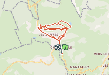

Length
19.4 km

Max alt
1809 m

Uphill gradient
832 m
Km-Effort
30 km

Min alt
1557 m

Downhill gradient
828 m
Boucle
Yes
Creation date :
2025-05-09 13:56:17.934
Updated on :
2025-05-09 16:18:04.231
2h21
Difficulty : Medium

FREE GPS app for hiking
 SityTrail
IGN / Geographical institutes
SityTrail Plus
The world is yours!
About
Trail Mountain bike of 19.4 km to be discovered at Auvergne-Rhône-Alpes, Savoy, Hauteluce. This trail is proposed by m.rozeron.
Positioning
Country:
France
Region :
Auvergne-Rhône-Alpes
Department/Province :
Savoy
Municipality :
Hauteluce
Location:
Unknown
Start:(Dec)
Start:(UTM)
309189 ; 5069174 (32T) N.
Comments