


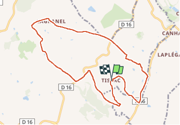
Tissac pr3

Glurps
User

Length
11.1 km

Max alt
244 m

Uphill gradient
253 m
Km-Effort
14.4 km

Min alt
132 m

Downhill gradient
255 m
Boucle
Yes
Creation date :
2025-05-10 09:31:51.0
Updated on :
2025-05-10 13:02:56.912

FREE GPS app for hiking
 SityTrail
IGN / Geographical institutes
SityTrail Plus
The world is yours!
About
Trail of 11.1 km to be discovered at Occitania, Tarn-et-Garonne, Cazes-Mondenard. This trail is proposed by Glurps.
Photos


Positioning
Country:
France
Region :
Occitania
Department/Province :
Tarn-et-Garonne
Municipality :
Cazes-Mondenard
Location:
Unknown
Start:(Dec)
Start:(UTM)
360414 ; 4898802 (31T) N.
Comments