


valbonnais -pont des fayolles

maupassant38
User
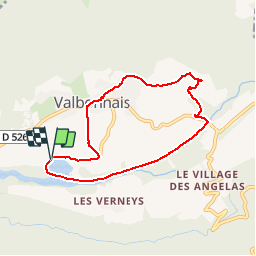

Length
7.1 km

Max alt
860 m

Uphill gradient
159 m
Km-Effort
9.2 km

Min alt
703 m

Downhill gradient
159 m
Boucle
Yes
Creation date :
2019-02-22 22:31:29.044
Updated on :
2019-02-22 22:31:29.056
1h59
Difficulty : Easy

FREE GPS app for hiking
 SityTrail
IGN / Geographical institutes
SityTrail Plus
The world is yours!
About
Trail Walking of 7.1 km to be discovered at Auvergne-Rhône-Alpes, Isère, Valbonnais. This trail is proposed by maupassant38.
Positioning
Country:
France
Region :
Auvergne-Rhône-Alpes
Department/Province :
Isère
Municipality :
Valbonnais
Location:
Unknown
Start:(Dec)
Start:(UTM)
728813 ; 4975131 (31T) N.
Comments