


Queyras-Canal Rouchas Frach-Col du Clot du Loup

nicolas54230
User
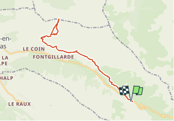

Length
19.7 km

Max alt
2651 m

Uphill gradient
761 m
Km-Effort
30 km

Min alt
2153 m

Downhill gradient
761 m
Boucle
Yes
Creation date :
2025-05-12 08:38:31.771
Updated on :
2025-05-12 08:40:23.506
6h47
Difficulty : Very difficult

FREE GPS app for hiking
 SityTrail
IGN / Geographical institutes
SityTrail Plus
The world is yours!
About
Trail Walking of 19.7 km to be discovered at Provence-Alpes-Côte d'Azur, Hautes-Alpes, Molines-en-Queyras. This trail is proposed by nicolas54230.
Positioning
Country:
France
Region :
Provence-Alpes-Côte d'Azur
Department/Province :
Hautes-Alpes
Municipality :
Molines-en-Queyras
Location:
Unknown
Start:(Dec)
Start:(UTM)
336978 ; 4951673 (32T) N.
Comments