


Queyras-Abriès-Collette et Crête de Gilly-Etang de Moussou

nicolas54230
User
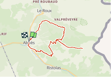

Length
18.5 km

Max alt
2583 m

Uphill gradient
1148 m
Km-Effort
34 km

Min alt
1543 m

Downhill gradient
1149 m
Boucle
Yes
Creation date :
2025-05-12 08:52:20.363
Updated on :
2025-05-12 08:53:44.838
7h41
Difficulty : Very difficult

FREE GPS app for hiking
 SityTrail
IGN / Geographical institutes
SityTrail Plus
The world is yours!
About
Trail Walking of 18.5 km to be discovered at Provence-Alpes-Côte d'Azur, Hautes-Alpes, Abriès-Ristolas. This trail is proposed by nicolas54230.
Positioning
Country:
France
Region :
Provence-Alpes-Côte d'Azur
Department/Province :
Hautes-Alpes
Municipality :
Abriès-Ristolas
Location:
Unknown
Start:(Dec)
Start:(UTM)
336133 ; 4962222 (32T) N.
Comments