


Puivert a Roquefeuil

avdem
User
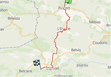

Length
21 km

Max alt
950 m

Uphill gradient
661 m
Km-Effort
28 km

Min alt
473 m

Downhill gradient
204 m
Boucle
No
Creation date :
2025-05-13 06:14:26.792
Updated on :
2025-05-13 14:35:16.287
8h19
Difficulty : Easy

FREE GPS app for hiking
 SityTrail
IGN / Geographical institutes
SityTrail Plus
The world is yours!
About
Trail Walking of 21 km to be discovered at Occitania, Aude, Puivert. This trail is proposed by avdem.
Description
long
Positioning
Country:
France
Region :
Occitania
Department/Province :
Aude
Municipality :
Puivert
Location:
Unknown
Start:(Dec)
Start:(UTM)
422185 ; 4752457 (31T) N.
Comments