


Givrées trail

SERGIO110_1
User
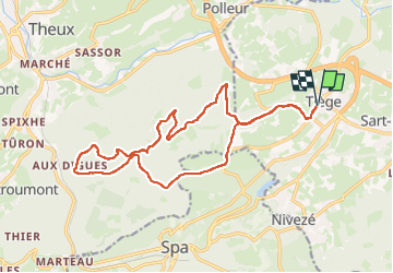

Length
17.1 km

Max alt
367 m

Uphill gradient
388 m
Km-Effort
22 km

Min alt
222 m

Downhill gradient
389 m
Boucle
Yes
Creation date :
2025-05-14 05:45:00.176
Updated on :
2025-05-14 05:45:02.838

FREE GPS app for hiking
 SityTrail
IGN / Geographical institutes
SityTrail Plus
The world is yours!
About
Trail of 17.1 km to be discovered at Wallonia, Liège, Jalhay. This trail is proposed by SERGIO110_1.
Positioning
Country:
Belgium
Region :
Wallonia
Department/Province :
Liège
Municipality :
Jalhay
Location:
Unknown
Start:(Dec)
Start:(UTM)
706141 ; 5600543 (31U) N.
Comments