


villette 15.05.2025

jcb48
User

Length
6.7 km

Max alt
361 m

Uphill gradient
136 m
Km-Effort
8.5 km

Min alt
257 m

Downhill gradient
132 m
Boucle
Yes
Creation date :
2025-05-14 07:45:26.208
Updated on :
2025-05-14 07:46:09.726
1h55
Difficulty : Easy

FREE GPS app for hiking
 SityTrail
IGN / Geographical institutes
SityTrail Plus
The world is yours!
About
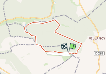
Trail On foot of 6.7 km to be discovered at Grand Est, Meurthe-et-Moselle, Villette. This trail is proposed by jcb48.
Description
randonnee
Positioning
Country:
France
Region :
Grand Est
Department/Province :
Meurthe-et-Moselle
Municipality :
Villette
Location:
Unknown
Start:(Dec)
Start:(UTM)
686718 ; 5484459 (31U) N.
Comments