


PAYRAC

CANON2
User
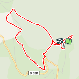

Length
5.6 km

Max alt
1007 m

Uphill gradient
169 m
Km-Effort
7.8 km

Min alt
877 m

Downhill gradient
166 m
Boucle
Yes
Creation date :
2019-05-15 13:08:30.549
Updated on :
2019-05-15 13:08:30.751
1h42
Difficulty : Easy

FREE GPS app for hiking
 SityTrail
IGN / Geographical institutes
SityTrail Plus
The world is yours!
About
Trail Walking of 5.6 km to be discovered at Occitania, Tarn, Nages. This trail is proposed by CANON2.
Positioning
Country:
France
Region :
Occitania
Department/Province :
Tarn
Municipality :
Nages
Location:
Unknown
Start:(Dec)
Start:(UTM)
480208 ; 4833387 (31T) N.
Comments