


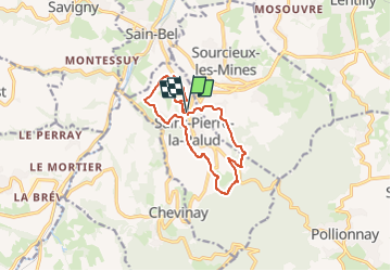
Saint-Pierre-la-Palud

Jean-Marc C
User

Length
11.3 km

Max alt
543 m

Uphill gradient
362 m
Km-Effort
16.2 km

Min alt
326 m

Downhill gradient
361 m
Boucle
Yes
Creation date :
2025-05-14 19:21:14.863
Updated on :
2025-05-14 19:22:26.129
3h40
Difficulty : Easy

FREE GPS app for hiking
 SityTrail
IGN / Geographical institutes
SityTrail Plus
The world is yours!
About
Trail On foot of 11.3 km to be discovered at Auvergne-Rhône-Alpes, Rhône, Saint-Pierre-la-Palud. This trail is proposed by Jean-Marc C.
Positioning
Country:
France
Region :
Auvergne-Rhône-Alpes
Department/Province :
Rhône
Municipality :
Saint-Pierre-la-Palud
Location:
Unknown
Start:(Dec)
Start:(UTM)
625200 ; 5072321 (31T) N.
Comments