


Beau

raygautier
User

Length
19.3 km

Max alt
1289 m

Uphill gradient
1198 m
Km-Effort
35 km

Min alt
503 m

Downhill gradient
1189 m
Boucle
Yes
Creation date :
2025-05-15 06:53:46.0
Updated on :
2025-05-15 17:01:20.668
9h27
Difficulty : Very difficult

FREE GPS app for hiking
 SityTrail
IGN / Geographical institutes
SityTrail Plus
The world is yours!
About
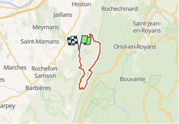
Trail Walking of 19.3 km to be discovered at Auvergne-Rhône-Alpes, Drôme, Beauregard-Baret. This trail is proposed by raygautier.
Description
Beauegard
Positioning
Country:
France
Region :
Auvergne-Rhône-Alpes
Department/Province :
Drôme
Municipality :
Beauregard-Baret
Location:
Unknown
Start:(Dec)
Start:(UTM)
673246 ; 4984425 (31T) N.
Comments