


Boffres

raygautier
User
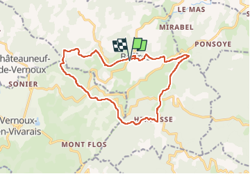

Length
16.5 km

Max alt
812 m

Uphill gradient
484 m
Km-Effort
23 km

Min alt
573 m

Downhill gradient
486 m
Boucle
Yes
Creation date :
2025-05-17 07:24:48.0
Updated on :
2025-05-17 11:54:15.865
4h28
Difficulty : Very difficult

FREE GPS app for hiking
 SityTrail
IGN / Geographical institutes
SityTrail Plus
The world is yours!
About
Trail Walking of 16.5 km to be discovered at Auvergne-Rhône-Alpes, Ardèche, Boffres. This trail is proposed by raygautier.
Positioning
Country:
France
Region :
Auvergne-Rhône-Alpes
Department/Province :
Ardèche
Municipality :
Boffres
Location:
Unknown
Start:(Dec)
Start:(UTM)
634248 ; 4975394 (31T) N.
Comments