


celles version 2

ISAGIL
User
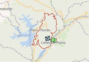

Length
15.9 km

Max alt
564 m

Uphill gradient
484 m
Km-Effort
22 km

Min alt
306 m

Downhill gradient
484 m
Boucle
Yes
Creation date :
2025-05-17 07:15:05.155
Updated on :
2025-05-17 14:01:07.758
6h44
Difficulty : Very difficult

FREE GPS app for hiking
 SityTrail
IGN / Geographical institutes
SityTrail Plus
The world is yours!
About
Trail Walking of 15.9 km to be discovered at Grand Est, Vosges, Celles-sur-Plaine. This trail is proposed by ISAGIL.
Description
Pierre percee
Positioning
Country:
France
Region :
Grand Est
Department/Province :
Vosges
Municipality :
Celles-sur-Plaine
Location:
Unknown
Start:(Dec)
Start:(UTM)
348174 ; 5368811 (32U) N.
Comments