


A la découverte de Saint Jean d'Aulps

micheldutilleul
User
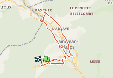

Length
8.9 km

Max alt
948 m

Uphill gradient
307 m
Km-Effort
13 km

Min alt
762 m

Downhill gradient
307 m
Boucle
Yes
Creation date :
2025-05-17 19:36:30.868
Updated on :
2025-05-17 19:48:05.094
2h57
Difficulty : Difficult

FREE GPS app for hiking
 SityTrail
IGN / Geographical institutes
SityTrail Plus
The world is yours!
About
Trail Walking of 8.9 km to be discovered at Auvergne-Rhône-Alpes, Upper Savoy, Saint-Jean-d'Aulps. This trail is proposed by micheldutilleul.
Positioning
Country:
France
Region :
Auvergne-Rhône-Alpes
Department/Province :
Upper Savoy
Municipality :
Saint-Jean-d'Aulps
Location:
Unknown
Start:(Dec)
Start:(UTM)
318134 ; 5121892 (32T) N.
Comments